Water Quality by Distribution Area
The SCWA service area, all the areas we supply water to, is divided into 26 distinct geographical areas called Distribution Areas. Choose a location from the community list below to obtain the water quality information from one of these Distribution Areas. The range of readings shows the lowest value for a detected compound, the highest value, the average value, and the total number of tests performed in the Distribution Area selected.
Return to Water Quality Report
Jump to community by letter
A B C D E F G H I K L M N O P Q R S T W Y
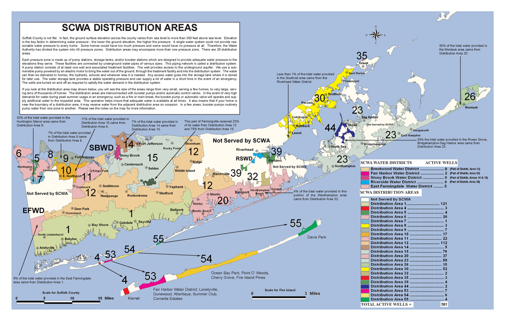 (view full size PDF)
Select your community below to view it's distribution area report
A
B
Bayshore, North Bayshore, West Bayshore, Brightwaters
Bellport, North Bellport, West Bellport
- South of Sunrise Hwy and a small area north of Sunrise Hwy, east of C.R. 101/Patchogue Yaphank Ave.) west of Station Rd. up to and including Harrison Ave. but excluding the outlet mall.
- Bellport North of Sunrise Hwy. (except area noted above)
Bohemia
Brentwood, Edgewood (Heartland Industrial Park)
Brentwood All other Southern or Western Brentwood areas
Bridgehampton, Sag Harbor
Bridgehampton, Scuttlehole
Brookhaven
C
Centerport
- N. of, W. of, or on, Old Field Rd. or Centerport Rd.
- N. of, or on Harbor Circle; W. of, or on, Ft. Salonga Rd. or Washington St. (S. of this area is Greenlawn Water District)
Centereach, South Centereach
- Centereach - All areas S. and / or W. of Nichols Rd. and E. of, but not on
Washington Ave.
South Centereach - N. of Wanda Terrace, Linden Ln., Grendon Ln., Hermart Ln., Crossover Dr., Peak St., Northfield Dr., W. of Morris Ave., E. of “C” St., and S. of Portion Rd., only. - Centereach - Includes N. and S. Centereach. Areas S. of, but not on,
Middle Country Rd. and / or on, or W. of, Washington Ave.
South Centereach - S. of Wanda Terrace, Linden Ln., Grendon Ln., Hermart Ln., Crossover Dr., Peak St., Northfield Dr., W. of “C” St., and S. of Portion Rd. only.
Commack
Commack, East Commack
Coram, Gordon Heights
Coram
Corneille Estates, Fire Island
Cutchogue
D
Deer Park
- (All areas S. of LIRR not covered below)
- All areas N. of LIRR. Also area S. of LIRR E. of or on Carll’s Path, S. to Grand Blvd. then, E. along Grand Blvd. to Commack Rd., then all areas accessible from Grand Blvd. N. of, but not on Crossway Dr. and / or Headline Rd. to the Babylon town line. (Including all areas N. to Dix Hills Water District)
E
East Farmingdale Water District
East Hampton
East Northport
East Setauket
- N. or E. of LIRR; N. or W. of Hulse Rd. or California Ave.
- East Setauket (South Setauket)
S. of LIRR; Hulse Rd., Canterbury Ct.; E. of, or on, California Ave., S. of
N. Country Rd. from California Ave. E.
Eastport
F
Fair Harbor Water District, Fire Island
Farmingville
- S. of Horse Block Rd., N. of, or on, Horse Block Rd., W. of Berkshire Ave., W. of, or on, Roberta Ave, S. of Rutgers Rd & Fourth St, E. of Waverly Av, Columbus Ave, & Eton Rd, N. of Portion Rd & Campus Dr.
- N. of, or on, Horse Block Rd., E. of Berkshire Dr.
Flanders
G
Great River, Great River North
Great River North
H
Holbrook, East Holbrook
Holbrook, South Holbrook
Huntington, E. Huntington, E. Neck, W. Neck, Lloyd Harbor, Lloyd Neck, Huntington Station
- (Greater Huntington Area; includes portions of
Huntington Station. Various smaller areas within the greater Huntington
area are further subdivided and described in subsequent entries. Read
all entries to determine the appropriate zone)
- Starting at the Nassau-Suffolk border by Cold Spring Harbor; N. of, on, and W. of, Saw Mill Rd. or Snowball Dr., E. or N. of Woodchuck Hollow; N. of Rogues Path (W. 11th Rd. and E. 11th Streets) or N. of Pulaski Rd. near Park Ave.; N.W. of Whitson and / or Lake Rds.; N.W. of, but not on, Old Field Rd. up to Centerport Harbor.
- Huntington (Includes northern portions of Huntington Station. Read all entries to determine the appropriate distribution area). Areas E. of Hawkhurst, Rancher Pl., N. of E. 10th / E. 11th St., W. of Algonquin Dr., Osage Dr., and Park Ave., S. of Columbia Ave & Olive St.
- Huntington (Rte. 110 / New York Ave.corridor in Huntington Village) Areas S. or E. of the intersection of W. Shore Rd. and Mill Dam Rd., E. of, or on Wall St. N. of Main. St., E. of Woodbury Rd., S. of Main St. but N. of High St.; N. of High St. or Dewey St., W. of but not on Spring Rd., N. to New York Ave. at Madison St., N. along both sides (about 1 block deep on E. side) of New York Ave. to and including, Young’s Hill Rd., then N. including the area, and all streets, from Huntington Harbor shoreline E. to, but not including, Huntington Bay Rd.; then N. to the Huntington Bay Village Boundary (near Castle Harbor Ct., Bay Rd.)
Huntington Bay (Village of)
Huntington Bay
Huntington (Half Hollow Hills and East Half Hollow Hills)
Huntington (Huntington Manor)
I
K
Kings Park
- E. of Sunken Meadow Pkwy., S. of E. Northport Rd. and or Old Dock Rd., E. to boundary with Smithtown Water District.
- E. of Sunken Meadow Pkwy., N. of E. Northport Rd., Main St. (Rte. 25A), N and W along Old Dock Rd.; Includes areas N. along Kohr Rd. but S. of Valley Cedar Pl.
- N. of the other two Kings Park areas, to the coast, includes the coastal end of the Dock Rds.
L
Lake Grove
- S. of Middle Country Rd. (Rte. 25) Also the neighborhoods
N. of Middle Country Rd. accessed from Deitz Rd.,
New Holmstead Rd., Hawkton Pl. or Stony Brook Rd. S. of Hawk or Renown St., All areas E. of Stony Brook Rd.
in zip code 11755. - Areas N. of Middle Country Rd and Rte 347 between Cambon Ave. (on the west) and Moriches Rd. (on the East) N. to Gordons Gate, Aesop La., and Glen Hill. All areas N. of Middle Country Rd. (Rte. 25) within the Township of Brookhaven.
Lake Ronkonkoma
- Most of area except Cenacle of St. Regis and points east. Includes all
areas and cul-de-sac accessible from Gatelot Ave., Sachem H.S. and
areas N. of Smith Rd. W. of Sachem H.S. and E. to Balaton Ave. Then all
areas N. of but not on
Smith Rd. - Areas west of the Cenacle of St. Regis (west to Hawkins Rd, north to Smith St and south to Portion Road) and points east. Areas S. of Smith Rd. E. of Sachem H.S. Then all areas on or S. of Smith Rd. The numbered streets and lettered avenues on both sides of Holbrook Rd. and areas just E. and just W. of those streets adjacent to Portion Rd.
Lindenhurst, North Lindenhurst
M
Mastic
Mattituck (Greater Mattituck Area) Includes Captain Kidd Estates.
Medford
- Northern-most area: Areas along Coram and Yaphank Rd. Areas accessed from either Greentree Dr. off of Mill Rd., or from Bellport La. N. to Coram Hill and Coram.
- S. of and including, Horseblock Rd. Areas on Rte 112, not including
Middle Island Rd. Area E. of Middle Island Rd. but S. of, or off of, Granny
Rd., E. to intersection with Bellport Ave. and Mill Ave., E. along N. Dunton
to Country Rd. E. along Mill Rd. but not including Bellport La., Greentree
Dr. or areas N. (these are covered in Distribution Area 15). •
Also, all areas to the south and west of the area above, down to the
intersection of North Ocean Ave and Bayside Blvd, then east along
Bayside Blvd to Old Medford Ave; includes all areas east of Old Medford all areas N. and E. of Fish Ave and north of East Woodside, then east to include Thicket Rd., or Sunrise Hwy., E. to C.R. 101 / Patchogue-Yaphank Rd., Sills Rd., N. to Harrison Ave., E. along Harrison to Bellport Station Rd.
Middle Island
- W. of, but not including, Miller Place-Yaphank Rd. or Middle Island Rd.
- On, or E. of, Miller Place-Yaphank Rd. and on or N. of, Longwood Rd.
- On or E. of Miller Place-Yaphank Rd. and S. of Longwood Rd.
Montauk, Montauk Beach
N
Nissequogue, Southwest Head of the Harbor
Nissequogue, Head of the Harbor, Western Head of the Harbor,
Southwest Saint James
Northport
- On, W. of, or N. of, James, Bayview, Woodbine, or Fort Salonga Rds., W. of, but not on, Reservoir Rd.
- Areas off of, E. of, or on, Reservoir Ave. or Laurel Rd. between Fort Salonga Rd. and Scudder Ave.; S. of Fort Salonga Rd. or Middleville Rd. E. of Vernon Valley Rd.
Northport, Asharoken, Crab Meadow, Eatons Neck, Fort Salonga
O
P
Patchogue, E. Patchogue, Hagerman (Includes Village of Patchogue)
Patchogue, North
Pilgrim State Psychiatric Center
Port Jefferson
Port Jefferson, Belle Terre
Port Jefferson Station, Terryville
Q
R
Riverside (Suffolk County Comm. College)
S
Sag Harbor (includes the Village of Sag Harbor), Bridgehampton
Saint James, Western Saint James
Saint James
Setauket, Poquott
Setauket, South Setauket
Shirley
Shirley, North
Shoreham
- Northern area of village; and Overhill Rd., Ashley La., Soundview Dr., Mary Pitkin Path and all points N., includes East Shoreham. Excludes areas shown below.
- Areas W. of village. Also includes part of village and area E. as follows: W. of South Gate on or off of Woodville Rd. N. to and including Suffolk Down or areas on or off of Briarcliff Rd. N. to Ashley La. or Soundview Dr.
Smithtown, Village of the Branch
Southampton, Roses Grove
Southold, Bayview (Except Browns Hills)
Stony Brook, South Stony Brook
T
W
Wading River (Brookhaven Side)
West Babylon
Westhampton (all areas except below)
Westhampton
Wyandanch, Wheatley Heights
Y
Yaphank, West Yaphank, East Yaphank, South Yaphank
Yaphank, East
Yaphank, South (includes South Haven)